Connect this guide with the rest of your visit in the Milan trip planner. Read how the research is made and what its sources establish.
At a glance
Start here
- The Navigli linked Milan with wider waterways, canal-side municipalities, and regional territory.
- Candoglia marble reached the cathedral works through the Naviglio Grande and inner waterways.
- Locks made changes in water level part of the city’s engineering history.
- Visible canals are surviving pieces of a much larger, partly covered system.
01
Begin with a network, not a nightlife district
Regional planning records identify five Lombardy Navigli: Grande, Martesana, Pavese, Bereguardo, and Paderno, together with connected waterways. Their functions and dates differ, but the shared idea is territorial connection. The territorial plan follows the network across 51 municipalities, while current navigation rules treat canals and connected waterways as a managed system.
The two canals meeting the Darsena are therefore an urban endpoint rather than the whole story. A present-day walk along the Naviglio Grande or Pavese becomes clearer when you imagine motion beyond the city: water arriving, cargo transferring, boats turning, and maintenance regimes extending across municipalities. The canal bank was an edge of a working system.
- Read the Darsena as a junction.
- Connect each visible canal with its wider water source and territory.
- Separate the historic network from the modern district label.
02
The Naviglio Grande made regional movement tangible
The regional territorial plan lists the municipalities along the Naviglio Grande from the Ticino side toward Milan and treats the canal as a landscape and planning system rather than an isolated attraction. That long line puts the final urban stretch in context: the canal crosses a chain of municipalities before reaching Milan.
When standing near the Darsena, reverse the usual viewpoint. Instead of looking outward from a fashionable city neighborhood, look inward from the region. The documented marble route makes that scale concrete, linking a distant quarry, river and lake passages, the Naviglio Grande, and docks in Milan.
- Trace the canal westward on a regional map.
- Look for towpaths, bridges, and changes in bank form.
- Think about travel time and cargo rather than only scenery.
03
The Duomo’s marble reveals the freight system
The Veneranda Fabbrica’s Candoglia Quarry history gives the clearest material example. In 1387 Gian Galeazzo Visconti granted the quarry’s use and free water transport. Marble traveled from the Toce to Lake Maggiore, then along the Ticino and Naviglio Grande to the Sant’Eustorgio docks, continuing through locks toward the Laghetto near the cathedral site.
This route makes the Duomo and Navigli parts of the same construction story. The cathedral’s pale stone came from outside Milan, but waterways brought it into the urban core. The Fabbrica states that water transport continued until 1920 before road transport replaced it. A canal walk can therefore be read as a supply-chain history written into the city’s most famous monument.
- Connect quarry, river, lake, canal, dock, and building site.
- Remember that monumental architecture depends on logistics.
- Use the cathedral’s stone as evidence of Milan’s regional reach.
04
Locks turned changing levels into navigable routes
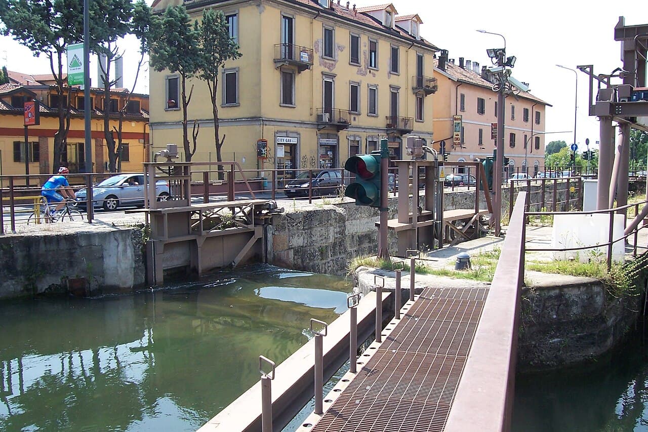
A model in the National Museum of Science and Technology’s collection explains mitre gates used to close canal locks and regulate water flow. Its record links Leonardo’s drawing from around 1506 to the San Marco lock on the urban end of the Martesana. The museum carefully presents his study as either an improvement or a record of a recently built mechanism.
That qualification matters. Leonardo belongs in the Navigli story, but not as a magical inventor detached from other engineers. The urban Martesana became navigable through three locks attributed to ducal engineer Bartolomeo Della Valle. Leonardo’s detailed drawing documents a technical system that would remain in canal use for centuries. Engineering here was cumulative, observed, adapted, and maintained.
- Treat Leonardo’s drawing as evidence, not a creation myth.
- Look for surviving names that recall locks and docks.
- Ask how water level, gate pressure, and boat passage interacted.
05
Covering canals changed the city without erasing water
Milan’s visible canal landscape is incomplete. The inner routes that carried water and cargo toward central docks were covered or transformed, while the Grande, Pavese, and parts of the Martesana remain open. The Duomo’s marble-yard history notes that after the nearby canal stretch was covered, the yard moved first to the docks on Viale Gorizia and later toward Certosa after road transport replaced water.
The quarry history names the Laghetto near the cathedral as the marble route’s inner endpoint, while the marble-yard history records later moves after canal covering and the switch to roads. Regione Lombardia’s Civil Engineering archive preserves records on maintenance, structures, water derivations, and state property across the Navigli. That bureaucratic record is valuable: canals depended on routine administration and repair, not only on celebrated construction moments.
- Compare a current map with a historical water-route map.
- Notice curved streets and place names that outlasted the water.
- Include maintenance history alongside construction history.
06
Read today’s Navigli as living infrastructure
The canals still have regulated navigation roles. Regione Lombardia describes public navigation routes and warns that services may face temporary limits caused by seasonal or extraordinary water conditions. It also identifies the competent management authority and links current maps and rules. A canal that looks leisurely from the bank still belongs to an operational system.
Walk in daylight if your purpose is to read engineering and urban form. Start at the Darsena, follow one bank, compare bridge positions, and stop where buildings meet the towpath. For any boat service, verify the current operator, route, water conditions, and ticketing on the official linked pages. History explains the system; it does not guarantee present access.
- Use current official navigation maps for active routes.
- Expect water conditions and maintenance to affect service.
- Choose one canal branch for close observation rather than rushing both.
Useful answers
Reader questions
Were Milan’s Navigli built only for transport?
No. The regional pages document navigation, territorial planning, maintenance, structures, and water derivations across the network. Individual canals had different origins and functions, so the system should not be reduced to one purpose.
Sources: Regione Lombardia; Regione Lombardia; Regione LombardiaDid Duomo marble travel along the Navigli?
Yes. The Veneranda Fabbrica records a route from the Toce through Lake Maggiore, the Ticino, and Naviglio Grande to Milan, then through inner waterways toward the cathedral works.
Sources: Veneranda Fabbrica del Duomo di Milano; Veneranda Fabbrica del Duomo di MilanoDid Leonardo invent Milan’s canal locks?
The museum record is more cautious. It connects his circa-1506 drawing to the San Marco lock and says it may document or improve an existing gate system; it also credits Bartolomeo Della Valle with the three locks that helped make the urban Martesana navigable.
Sources: Museo Nazionale Scienza e Tecnologia Leonardo da VinciCan visitors still navigate the Navigli?
Some public tourist navigation routes operate, but routes can face temporary water-related limits. Check Regione Lombardia’s current navigation page and the official operator information it links before planning a boat trip.
Sources: Regione LombardiaRead the evidence
Sources and further reading
These sources support the relevant sections above. Plans and comparisons are editorial suggestions. Check operators for current arrangements.
- Piano Territoriale Regionale d’Area Navigli Lombardi ↗Regione Lombardia · Research date 14 September 2026
Regional planning frame, canal territories, municipalities along the Naviglio Grande, and landscape-system context.
- Genio Civile di Milano: Navigli lombardi ↗Regione Lombardia · Research date 14 September 2026
Archival record of maintenance, canal structures, water derivations, property, and administrative management across the network.
- The Candoglia Quarry ↗Veneranda Fabbrica del Duomo di Milano · Research date 14 September 2026
1387 quarry grant and exact marble transport route through lake, rivers, Naviglio Grande, Sant’Eustorgio dock, locks, and Laghetto.
- The Marble Yard ↗Veneranda Fabbrica del Duomo di Milano · Research date 14 September 2026
Marble-processing logistics and relocation of the yard after canal covering and the shift from water to road transport.
- Mitre lock gate ↗Museo Nazionale Scienza e Tecnologia Leonardo da Vinci · Research date 14 September 2026
Operation of mitre lock gates, Leonardo’s circa-1506 San Marco drawing, cautious attribution, and Bartolomeo Della Valle’s urban locks.